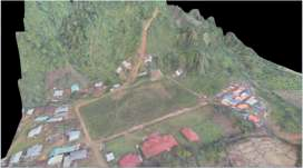
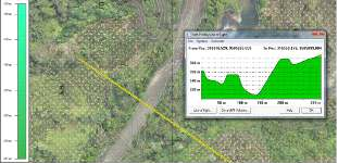
UAV Photogrammetry
DTM | Ortho photos | 3d model Aerial images | Summit observation
Digital Mapping and Survey offer a complete solution in providing high quality, accurate aerial data predominantly in the Indonesia. We also provide consultancy, data analysis or simply providing printed photos and maps. Our services and solutions are perfect for data acquisition of small to medium sized land areas in many applications including government or local authorities, engineering and construction projects, environmental monitoring and assessments, agriculture, sports and recreation, real estate and quarries.
Transport Infrastructure – Hi-Precision surveys of existing roads and rail lines to assist in the design process for realignments, upgrades and future civil works. Route corridor surveys to produce 3D models and DTMs for proposed infrastructure projects.
Health and Education – Surveys of existing hospitals and schools for record purposes or to be used in the design process for future development works.
Urban Regeneration – Surveys in highly congested areas such as cities and towns to produce precise 3D drawings of all features, services and structures for urban renewal/redevelopment projects.
Industrial and Commercial – Surveys of private Industrial and Commercial facilities to produce 2D and 3D drawings for record purposes or to be used in the design process for future development works. Surveys of brown/ green field sites for design and planning of new facilities.
Oil and Gas – Mapping of route corridors for new pipelines, green/brown field site surveys for new facilities, as built drawings of refineries.
Heritage – Surveys of national monuments, protected structures and state owned lands.
Private and Residential – Surveys of green/brown field sites for new developments such as housing schemes, hotels or commercial units. Surveys of individual private dwellings for architectural design works or planning purposes
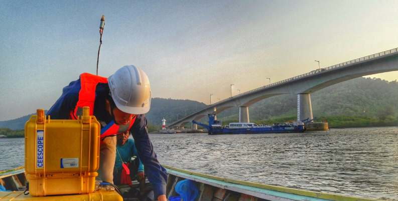
HYDROGRAPHIC SURVEY
Automatic water level recorded Telemetry | Bathymetry
FICS provides services to federal, state, and local agencies, international oil companies, and private industry for over-water developments. Projects range from ports, harbors, offshore wind, LNG terminals and platforms, to cable and pipeline landing sites. Services apply to inland studies of rivers, levees, reservoirs, and dams.
FICS survey capabilities benefit from continued investment in technological innovation. The group maintains global satellite coverage for the STARFIX and OMNISTAR differential global positioning systems (DGPS). In addition, FICS is the leader in the development of on-the-fly (or real time) Kinematic GPS (frequently referred to as OTF or RTK).
FICS provides a full scope of survey and related services around the world, including Land Surveys, Hydrographic Sur veys, Oceanographic Sur veys, Positioning and Navigation ser vices, Site Investigations, Cable and Pipeline Route Surveys, QC Surveys, Desktop Studies, etc. Services cover the Oil and Gas Industry, Infrastructure Projects, Subsea Telecommunications and Pipelines, etc.
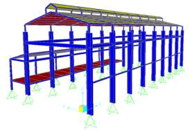
STRUCTURE & GEOTECHNICAL
FICs provides expertise in civil engineering to ensure the long-term safety, durability and stability of structures. We are experts in handling reinforced concrete, pre-stressed concrete, steel and composite structural design with extensive creative capabilities in engineering computer programs. We are capable of providing clear and accurate information on cost estimation and methods of construction, which enables clients' better coordination in structural design while concurrently implementing innovative ideas and techniques on various types of projects.
FICs also have capability to characterize the ground at a wide variety of sites is a major factor on the success, cost effective and long term safety of a project. Since soils and rocks are natural products, their physical properties are extremely varied in horizontal and vertical directions. Consequently, experience in dealing with various soil conditions is an important factor in geotechnical engineering.
FICs geotechnical engineers possess the knowledge and experience required for proper evaluation of the subsurface soils and rocks at a wide variety of sites and for carrying out various engineering analyses. We have provided geotechnical engineering services for a wide range of civil engineering projects, from high-rise buildings, industrial structures, roads and bridges, coastal development.
POWER PLANT & ENERGY
In response to the government's program to accelerate the availability of 35,000 MW electricity in 2030, FICs also prepared feasibility study and design review of Power Plant of several hydro project.
Hydro and coal Power Plant. In line with the Indonesian Government's policy to take the advantage of renewable energy, FICs received several assignments related to hydro power plants owned by private developers and the State Owned Electric Company (PLN).
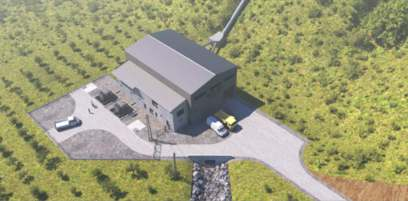
PLTA BLANG
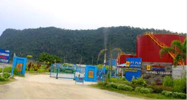
PLTU Holtecamp Papua
MECHANICAl& ELECTRICAL
MHPP Assessment
The purpose of assessment is to identify condition of existing Power Plant, detailed inspection of all component of hydraulic system, civil structure, mechanical and electrical equipment was carried out to describe current conditions. Visual inspection of each part on civil work, river condition, mechanical and electrical work are carried out while MHPP is running.
Visual inspection is first stage on engineering assessment for detecting any signs of physical defects, flood, ageing factor, crack, excessive seepage, leakage, landslide, sedimentation. Site investigation such as soil /drilling, topography, hydrology, river survey and mechanical on this project are conducted simultaneous with visual assessment. The following parts/subsystem are conducted on visual assessment: i) Upstream condition, ii) Dam and intake , iii) Sandtrap, iv)Waterway, v) Forebay, vi) Penstock, vii) Power house, viii) Tail race , ix) Down stream, x) Inspection road, and xi) Mechanical Electrical Equipment.
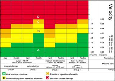
Inspection or monitoring of vibration is one technique that is sufficiently reliable to determine the condition of the turbines and generators. Abnormalities that can be inspected through the vibration are unbalanced, misalignment, and bearing abnormalities. Vibration inspection will be conducted with vibration scanner. Inspection results will be compared with the conditions of commissioning and ISO Standard 10816-3 Chart as below
To identify a possible cause, Root Cause Analysis Method will be employed. Root cause analysis (RCA) is a method of problem-solving used for identifying the root causes of faults or problems. A factor is considered a root cause if removal thereof from the problem-fault-sequence prevents the final undesirable event from recurring; whereas a causal factor is one that affects an event's outcome, but is not a root cause. Though removing a causal factor can benefit an outcome, it does not prevent its recurrence with certainty
The vibration measurements were conducted at 4 locations, 3 points for every location. The measurement locations are turbine non-drive end, turbine drive ends, generator non-drive end and generator drive end. The measurement points for every location are V, H, and A, which are represent vertical, horizontal and axial respectively. All vibration measurement conducted at maximum power generation. The measurement point depicted by Figure 2, and the result is listed in Table 1.
Construction Management
FICs offer a full range of services as part of a multi-disclipnary company, we have evolved particulary strong project management process and skills extending to program management. Our goal is to help effectively plan the scope, time and budget of the project and ensure smooth execution for on-time and cost effective delivery.
Our team monitor and oversight with contractor in he field, for accurate reporting to client and effective contractor performance. And give more attention on critical path and schedule using PDM. Our teams are equipped with state of the art surveying, inspections, and testing instruments along with the necessary understanding of project needs and regulatory requirement. All process are supported by accurate and timely documentations using paper works as well as software.